Mapping - Unit Assessment
Geography Resource Description
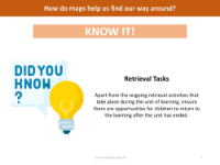
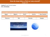
The Year 6 Geography unit on Map Work culminates in an assessment provided by Focus Education (UK) Ltd, which evaluates the students' understanding of maps and their features. The assessment covers several aspects of map knowledge, including digital mapping systems, the use of satellite imagery, interpretation of Ordnance Survey (OS) symbols, grid references, and time zones in relation to the United Kingdom.
Students are quizzed on what constitutes a Digimap, with options highlighting its nature as an online or electronic mapping system that can demonstrate changes in settlements over time. They must also identify what Google Earth relies on to function, such as satellite systems. The test includes tasks where pupils must match specific OS symbols to their meanings and find six-figure grid references for particular locations on a map. Additionally, they are asked to calculate time differences between the UK and various locations worldwide, considering whether these places are ahead or behind the UK time. This comprehensive assessment aims to ensure that students have a solid grasp of map-related concepts and can effectively use maps as geographical tools.