Mountains - Unit Assessment
Geography Resource Description
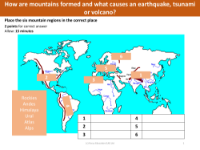
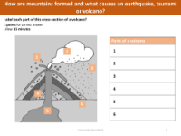
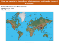
The "Knowledge of Mountains" assessment for Year 4 Geography students, created by Focus Education (UK) Ltd, is designed to evaluate their understanding of mountainous regions and related geological concepts. The assessment begins by asking students to name six mountain regions that are illustrated on a provided sheet, ensuring they can identify major mountain ranges. It then progresses to test their knowledge of the anatomy of a volcano by having them list the six parts of a volcano's cross-section showcased on another sheet. To assess their knowledge of local geography, students are asked to name two mountain regions within the UK and the height of Ben Nevis, with multiple-choice answers to choose from.
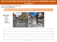
Further questions delve into the students' understanding of seismic activity, including what occurs during a strong earthquake, how to minimize earthquake damage, and the scale used to measure earthquakes. The assessment also seeks to determine whether students know where earthquakes are likely to occur and the typical location for experiencing strong earthquakes. Additionally, the students are tested on their map-reading skills with tasks such as marking the highest point, identifying steep cliffs or ridges, and locating lakes on a contour map. They are also asked to extract information from a road map, including naming cities, motorways, and other geographical features. This comprehensive assessment aims to cover a range of knowledge and skills related to mountains and the Earth's geology.