What is a county, and can I locate some of the UK’s main ones on a UK map? - Teacher's notes
Geography Resource Description
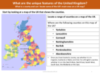
A county in the United Kingdom is a geographical and political subdivision used for administrative, cultural, and political purposes. In this unit, pupils are expected to understand the concept of a county and to be able to use maps to locate and identify various counties across the UK. They will also learn to recognize significant cities, towns, and distinct features within these counties. It's important for pupils to be able to place counties in relation to the cardinal directions as well as the commonly referred regions such as the South West, South East, North West, North East, the Midlands, and the East.
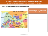
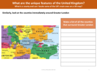
Further exploration involves examining the maps of Greater Manchester and Greater London, two significant metropolitan areas in the UK. Pupils will be tasked with identifying which counties are adjacent to these areas, enhancing their understanding of the UK's geographical layout. The goal is for pupils to not only be able to find and name the main counties on a UK map but also to grasp their locations in the broader context of the country's regional divisions and neighboring counties.