What is a county, and can I locate some of the UK’s main ones on a UK map? - Presentation
Geography Resource Description
A county within the United Kingdom is defined as an area that has its own form of local government. These counties are significant geographical divisions that can be found throughout the nation, each possessing unique characteristics and playing a vital role in the administrative and cultural structure of the country. The National Curriculum for Geography at Key Stage 2 requires students to name and locate the UK's counties, as well as its cities, geographical regions, and various physical features, understanding how these have evolved over time. Knowledge of counties is foundational for comprehending the UK's layout, including its rural and urban areas, and for appreciating why certain locations, like the Lake District or Stonehenge, are popular with tourists.
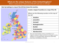
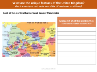
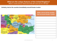
In Year 3 Geography, students are expected to use maps to identify a number of the UK's counties, recognizing their position in relation to the cardinal directions of north, south, east, and west. For instance, they should be able to locate counties such as Yorkshire, Lancashire, Cornwall, Nottinghamshire, Norfolk, Pembrokeshire, and Aberdeenshire, identifying which country they are part of and, for those in England, which region they belong to. Additionally, students will explore the counties that border major urban areas like Greater Manchester and Greater London. This geographical understanding is crucial for students to compare different environments within the UK and to appreciate the unique features that make up the nation's diverse landscape.