What are the features of the upper, middle and lower courses of a river? - Presentation
Geography Resource Description
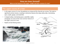
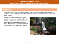
The journey of a river from its source to its mouth is divided into three distinct courses, each with unique geographical features. In the upper course, the river is characterised by steep gradients and narrow channels, which lead to powerful vertical erosion. This results in dramatic landscapes with V-shaped valleys, interlocking spurs, and the formation of waterfalls where water cascades over resistant rock layers. Rapids, with their fast-flowing waters, and gorges carved through the landscape are also typical of this stage. The formation of waterfalls involves the erosion of softer rock beneath harder capstones, eventually leading to the collapse of the overhang and the retreat of the waterfall, creating steep-sided gorges.
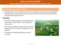
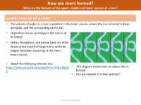
As we move to the middle course of a river, the gradient becomes gentler, and lateral erosion begins to dominate, widening the river channel and forming meanders—sinuous bends that snake across the landscape. The middle course is also where tributaries join the main river, increasing its volume and energy. In the lower course, the river reaches its fullest and slowest state, with a wide and deep channel flowing through flat land. Here, deposition outweighs erosion, leading to features like deltas, floodplains, and oxbow lakes, which are remnants of old meanders cut off from the main channel. These geographical features are not only fascinating in their own right but also provide a practical challenge for students, who are tasked with creating models to represent a waterfall, an oxbow lake, and a meandering river as part of their learning experience.