How do we use a local map to find the streets around the school? - Teacher notes
Geography Resource Description
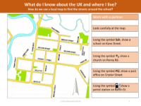
This unit is designed to equip children with the practical skills needed to navigate their local area using a map. The objective is to familiarise pupils with the concept of mapping and to help them identify key landmarks and streets around their school. Initially, the teacher will introduce an online resource, a video that explains the basics of reading and interpreting street maps. Following this, the pupils will be provided with a physical street map to engage in hands-on learning. They will use this map to locate important community features such as the school, post office, and other landmarks that the teacher chooses to include in the exercise.
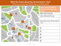
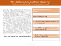
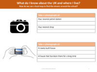
After gaining some confidence with real-world references, the lesson advances to using a fictional map. This helps the children learn the different types of streets, such as 'crescent', 'road', and 'avenue', enhancing their vocabulary and understanding of street nomenclature. The next step involves a more personal approach where pupils will use a map of the immediate vicinity of the school to pinpoint their own homes. This activity not only makes the learning experience more relevant but also encourages a sense of community and personal connection to the area. Fieldwork is an integral part of this unit, with students taking photographs of local places of interest and then placing these images onto the street map to create a visual and interactive representation. Additionally, they are encouraged to sketch an interesting local feature, with an example provided to set the expected standard. These activities combine to deepen the pupils' knowledge of their local area and the United Kingdom, as well as enhance their ability to use maps effectively.