Where are all the North American countries located? - Teacher notes
Geography Resource Description
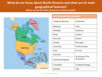
The lesson plan begins with an engaging introduction to the continent of North America, utilizing maps as a primary tool to identify and locate significant geographical features. The teacher will guide pupils in using a map of North America to pinpoint various countries, their capitals, prominent rivers, and mountain ranges. This interactive approach encourages pupils to actively participate by having them match the list of countries to their respective locations on the map. To further engage the students, they are prompted to colour-code the countries they are already familiar with differently from those that are new to them, enhancing their spatial awareness and memory retention.
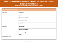
In addition to country locations, the lesson aims to deepen pupils' understanding of the major geographical features within North America, with a particular focus on the United States of America, Canada, and Mexico. For the USA, a more detailed map is provided, showing all the states and notable landmarks such as the Grand Canyon, to give pupils a comprehensive view of the country's topography. The lesson also places emphasis on ensuring pupils are knowledgeable about the main rivers and mountain ranges that traverse these three significant countries. This foundational geographic knowledge sets the stage for pupils to undertake a challenge: to research and learn more about a North American country they were not previously familiar with, thus broadening their global perspective and appreciation for the continent's diversity.