How can maps help us to find out about Blackpool and Blackburn? - Presentation
Geography Resource Description
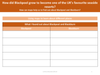
Maps are invaluable tools for exploring and understanding the geographical features and historical development of places such as Blackpool and Blackburn. By examining maps, students can discern the main differences between these two locations in the UK. In a presentation designed to educate pupils, they are encouraged to use maps to explore various aspects of both towns. For example, by focusing on physical geography, students can identify five key features of each location, such as landforms, bodies of water, and human-made structures. They are prompted to consider elements like scale, road networks, and the proximity to other towns and villages. All findings are to be recorded on a provided worksheet, fostering an interactive learning experience.
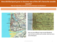
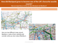
The presentation goes further by supplying two different maps for each of Blackpool and Blackburn. Students are tasked with scrutinizing these maps to extract information about each town. For Blackpool, known as one of the UK's favourite seaside resorts, maps can reveal how its geographical location and infrastructure contributed to its growth and popularity. Similarly, maps of Blackburn can provide insights into its own unique characteristics and development. By comparing and contrasting what they learn from the maps, students can gain a deeper understanding of how geography shapes the identity and evolution of places. The process of using maps to learn about different places culminates in a comparative analysis, where students can list their findings side by side for Blackpool and Blackburn, thus enhancing their geographic literacy and analytical skills.