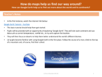
How can Google Earth help to find out more about the world and its continents? - Presentation
Geography Resource Description
Google Earth is an innovative tool that offers a virtual exploration of the world, allowing users to discover the diverse landscapes, climates, and biomes of the Earth's continents. By utilising satellite imagery and a 3D representation of the planet, Google Earth provides a comprehensive and interactive way to visualise and understand the world around us. Users can explore the program by entering specific addresses or coordinates, or by simply navigating with a keyboard or mouse. With coverage of over 98% of the global surface and an extensive collection of Street View images, Google Earth enables individuals to virtually travel from the comfort of their own homes, visiting locations such as their own school or street, following the journey of rivers from their sources to estuaries, and examining the distinct characteristics of different countries and continents.
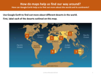
In addition to geographical exploration, Google Earth serves as an educational resource for studying the world's deserts and other biomes. Teachers can guide students in labelling and identifying deserts on a map, followed by virtual visits to these arid regions using Google Earth. This helps students to understand the environmental features and the continents on which these deserts are located. By using data such as average temperature and rainfall, learners can gain insights into the climatic conditions of each continent. Google Earth's comprehensive mapping capabilities not only assist in finding one's way around but also deepen the understanding of global geography, making it an invaluable tool for both educators and students alike.