Mapping
Unit
Geography
5th Grade
Focus Education
Geography Unit Description
Editable presentation
Group work
Active
Discussion based learning
5th Grade Geography unit, Mapping from Focus Education. This unit uses an enquiry-approach methodology, lessons are built around a central question in order to build pupil curiosity and motivate learning. Mapping has been constructed in accordance with the National Curriculum.
Unit contents
Overview Documents
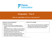
Long-term overview
Resource
Geography
5th Grade
The Long-term overview for the unit Mapping from Focus Education
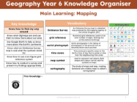
Knowledge organiser
Resource
Geography
5th Grade
The Knowledge organiser for the unit Mapping from Focus Education
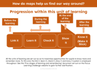
Progression pedagogy
Resource
Geography
5th Grade
The Progression pedagogy for the unit Mapping from Focus Education

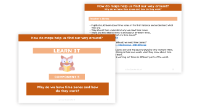
Link it! Prior knowledge
Resource
Geography
5th Grade
Link it! Prior knowledge is the set of initial activities that should be used to introduce the unit Mapping from Focus Education, it will allow pupils to link the upcoming learning to their existing skills and knowledge
Lessons
1. What are digimaps and how can they be used to help find out more about the local area?
Lesson
Geography
5th Grade
5th Grade Geography lesson from the unit Mapping. This lesson uses an enquiry-approach method, and will facilitate students answering the question 'What are digimaps and how can they be used to help find out more about the local area?'
2. How can Google Earth help to find out more about the world and its continents?
Lesson
Geography
5th Grade
5th Grade Geography lesson from the unit Mapping. This lesson uses an enquiry-approach method, and will facilitate students answering the question 'How can Google Earth help to find out more about the world and its continents? '
3. What are Ordinance Survey maps and what do the symbols stand for?
Lesson
Geography
5th Grade
5th Grade Geography lesson from the unit Mapping. This lesson uses an enquiry-approach method, and will facilitate students answering the question 'What are Ordinance Survey maps and what do the symbols stand for?'
4. How can I use six-figure grid references?
Lesson
Geography
5th Grade
5th Grade Geography lesson from the unit Mapping. This lesson uses an enquiry-approach method, and will facilitate students answering the question 'How can I use six-figure grid references?'
5. Why do we have time zones and how do they work?
Lesson
Geography
5th Grade
5th Grade Geography lesson from the unit Mapping. This lesson uses an enquiry-approach method, and will facilitate students answering the question 'Why do we have time zones and how do they work?'
Assessment for Learning Resources
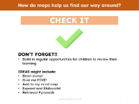
Check it!
Resource
Geography
5th Grade
Check it! is a set of assessment for learning tasks and assessments that should be used to check pupils' understanding of the learning during the course of the unit Mapping from Focus Education.
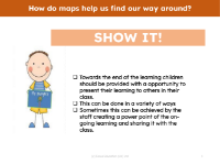
Show it! Group presentation
Resource
Geography
5th Grade
Show it! Group presentation is a group task that should be used to solidify student learning and should be run after the teaching of the lessons contained in the unit Mapping from Focus Education

Know it!
Resource
Geography
5th Grade
'Know it! - Mapping - 5th Grade' is a resource for assessing pupil knowledge at the end of the 5th Grade unit, Mapping
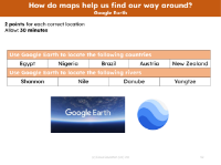
Locate these countries and rivers on Google Earth
Resource
Geography
5th Grade
'Locate these countries and rivers on Google Earth' is a resource for assessing pupil knowledge at the end of the 5th Grade unit, Mapping
Unit contents
Overview Documents
Long-term overview
Resource
Geography
5th Grade
The Long-term overview for the unit Mapping from Focus Education
Knowledge organiser
Resource
Geography
5th Grade
The Knowledge organiser for the unit Mapping from Focus Education
Progression pedagogy
Resource
Geography
5th Grade
The Progression pedagogy for the unit Mapping from Focus Education
Link it! Prior knowledge
Resource
Geography
5th Grade
Link it! Prior knowledge is the set of initial activities that should be used to introduce the unit Mapping from Focus Education, it will allow pupils to link the upcoming learning to their existing skills and knowledge
Lessons
1. What are digimaps and how can they be used to help find out more about the local area?
Lesson
Geography
5th Grade
5th Grade Geography lesson from the unit Mapping. This lesson uses an enquiry-approach method, and will facilitate students answering the question 'What are digimaps and how can they be used to help find out more about the local area?'
2. How can Google Earth help to find out more about the world and its continents?
Lesson
Geography
5th Grade
5th Grade Geography lesson from the unit Mapping. This lesson uses an enquiry-approach method, and will facilitate students answering the question 'How can Google Earth help to find out more about the world and its continents? '
3. What are Ordinance Survey maps and what do the symbols stand for?
Lesson
Geography
5th Grade
5th Grade Geography lesson from the unit Mapping. This lesson uses an enquiry-approach method, and will facilitate students answering the question 'What are Ordinance Survey maps and what do the symbols stand for?'
4. How can I use six-figure grid references?
Lesson
Geography
5th Grade
5th Grade Geography lesson from the unit Mapping. This lesson uses an enquiry-approach method, and will facilitate students answering the question 'How can I use six-figure grid references?'
5. Why do we have time zones and how do they work?
Lesson
Geography
5th Grade
5th Grade Geography lesson from the unit Mapping. This lesson uses an enquiry-approach method, and will facilitate students answering the question 'Why do we have time zones and how do they work?'
Assessment for Learning Resources
Check it!
Resource
Geography
5th Grade
Check it! is a set of assessment for learning tasks and assessments that should be used to check pupils' understanding of the learning during the course of the unit Mapping from Focus Education.
Show it! Group presentation
Resource
Geography
5th Grade
Show it! Group presentation is a group task that should be used to solidify student learning and should be run after the teaching of the lessons contained in the unit Mapping from Focus Education
Know it!
Resource
Geography
5th Grade
'Know it! - Mapping - 5th Grade' is a resource for assessing pupil knowledge at the end of the 5th Grade unit, Mapping
Locate these countries and rivers on Google Earth
Resource
Geography
5th Grade
'Locate these countries and rivers on Google Earth' is a resource for assessing pupil knowledge at the end of the 5th Grade unit, Mapping
Unlimited access to 30,000+ resources
All subjects
National Curriculum Coverage
Award-winning content
Explore other content in this scheme
Part of a scheme by Focus Education
Other units in this scheme
This website uses cookies to enhance the user experience.
To get more information about these cookies check our