How can I use six-figure grid references? - Presentation
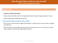
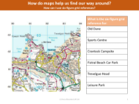
Understanding how to use six-figure grid references is an essential skill for accurately locating specific points on a map. Teachers guide pupils through the process, beginning with an instructional video that explains how to take both four-figure and six-figure grid references. Pupils then apply this knowledge to practical exercises, using an Ordnance Survey (OS) map to find and note the grid references of various landmarks, such as their school, local supermarket, or a nearby church. This hands-on approach helps students become familiar with the grid system and its application in real-world navigation.
The lesson extends to creating an accurate relief map reconstruction of a local area, which allows pupils to explore the topography of their surroundings in three dimensions. They start by identifying contour lines on a relief map and using tracing paper to outline specific elevations. Different coloured felt-tipped pens are used to distinguish various height levels, which are then transferred onto card of uniform thickness. As pupils layer these cards, they gradually build a 3D model of the area. The final steps involve painting or plastering the model to achieve a realistic representation, resulting in a tactile and visual tool that enhances their understanding of the terrain and their ability to interpret map features.