How do we use maps to locate the four countries of the UK, their capital cities and the main seas that surround the UK? - Presentation
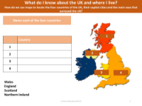
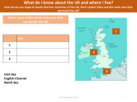
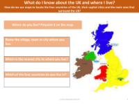
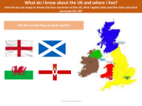
Maps are essential tools in geography, particularly when it comes to understanding the layout of the United Kingdom and its constituent parts. In Year 1, pupils learn to use world maps, atlases, and globes to identify the four countries that make up the UK: England, Northern Ireland, Scotland, and Wales. They also learn to locate the capital cities of these countries—London, Belfast, Edinburgh, and Cardiff respectively. Additionally, they are taught to recognise the main seas that border the UK, namely the Irish Sea, the English Channel, and the North Sea. This knowledge is further enriched by understanding simple compass directions and being able to use them to navigate maps.
Alongside map reading, pupils gain disciplinary knowledge, such as the importance of addresses and postcodes, and the ability to follow a simple road map. They are encouraged to observe and record information about their local environment, which might include undertaking fieldwork within their school locality. This could involve taking photographs of local geographical features or making a simple map that includes key landmarks. Through these activities, children develop a sense of place and learn to connect their personal experiences with the wider geographical context of the UK.