Long-term overview - Mountains - Year 4
The Year 4 Geography curriculum provides students with an in-depth exploration of physical and human geography, focusing particularly on mountains, and the phenomena of earthquakes and tsunamis. To meet the national curriculum requirements, pupils are expected to describe and understand key aspects of physical geography, such as the formation of mountains and the causes behind seismic activities like earthquakes and volcanoes. They also delve into human geography, learning about settlement types, land use, economic activities, and the distribution of natural resources. Students are taught to utilise various geographical tools including maps, atlases, globes, and digital mapping to identify countries and describe geographical features.
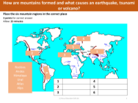
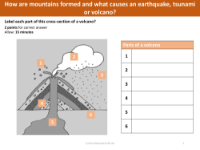
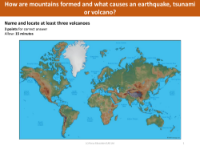
The substantive knowledge component of the curriculum ensures that students can name and locate at least eight European countries, identify major mountain regions in the UK, and understand global lines such as the Equator and the Greenwich Meridian. They appreciate the impact of climate and physical geography on human lifestyles and learn the scientific reasons behind earthquakes and tsunamis, as well as the parts of a volcano. Additionally, they familiarise themselves with some of the world's tallest mountains. The disciplinary knowledge extends to geographical skills and fieldwork, where students learn about relief maps, the concept of contours, and how to use maps to locate mountain regions. They also gain practical experience by creating sketches and models based on relief maps, helping them to visualise and understand the topography of mountainous landscapes.