How do we use maps to locate the four countries of the UK, their capital cities and the main seas that surround the UK? - Teacher notes
Geography Resource Description
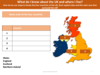
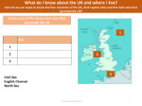
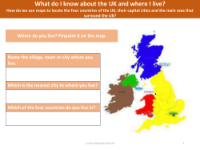
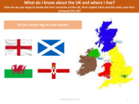
Maps serve as a fundamental tool in geography education, allowing pupils to visually explore and understand the layout of their own country. In a unit dedicated to map work, students are encouraged to familiarize themselves with the map of the United Kingdom. By examining a map or globe, they can start by identifying the UK's position in the world, followed by locating the four distinct countries that make up the UK: England, Scotland, Wales, and Northern Ireland. The exercise continues with pinpointing the three main seas that border the UK, which are the North Sea, the Irish Sea, and the Atlantic Ocean.
Building on this geographical foundation, the next step for pupils is to find the four capital cities of the UK: London, Edinburgh, Cardiff, and Belfast. This activity not only enhances their map-reading skills but also reinforces their knowledge of political geography. Teachers are encouraged to ensure that pupils are aware of their immediate surroundings, including their nearest village, town, or city, and comprehend which of the four UK countries they reside in. To conclude the unit, a visual aid in the form of an educational video provides an engaging summary of the United Kingdom, its geography, and its constituent parts. This multimedia approach helps to solidify the pupils' learning and understanding of their national geography.